 |
 |
Kent Online Parish Clerks |
|
 |
 All Saints at Birchington (Click photo for larger view) |
Acol Parish |
|
|
|
Kent Online Parish Clerks |
|
|
All Saints at Birchington (Click photo for larger view) |
Acol Parish |
|
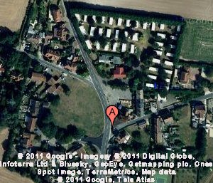 Click on map to view full size on Google Maps. |
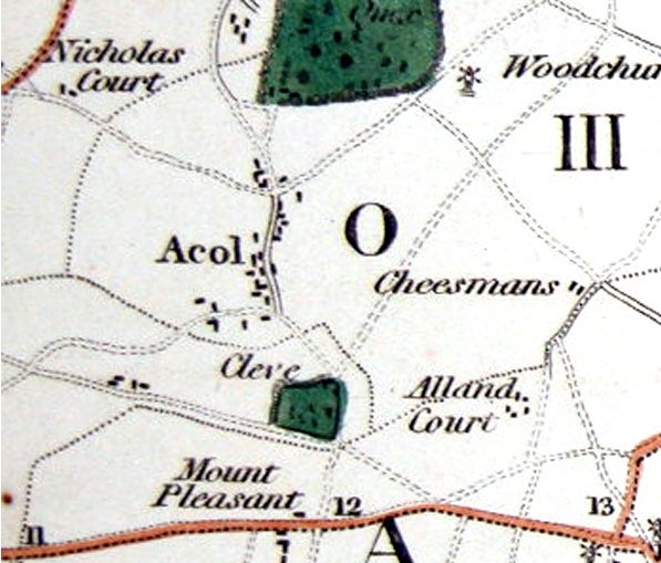
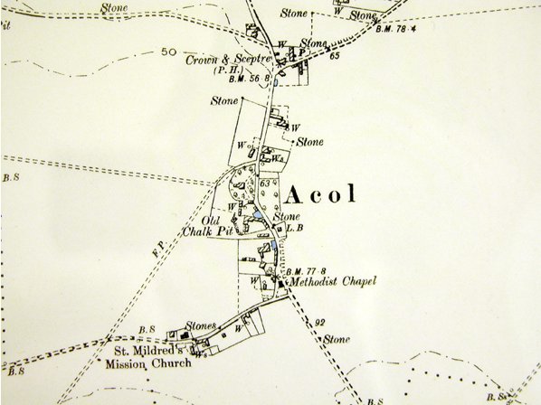 Click here for larger image of this 1881 survey. Click map for modern Ordnance survey map. Reproduced from Ordnance Survey map data by permission of Ordnance Survey, © Crown copyright. |
 We are sorry, there is no Online Parish Clerk for this parish. We are sorry, there is no Online Parish Clerk for this parish.We have no other information or data for this parish except what is accessed by or detailed on this page. If you wish to volunteer for this post or have data you wish to contribute, please use the appropriate link on our Contacts page. |
Statistical SummaryAcres: 1,434OS co-ordinates: TR307673 Latitude: 51:21.5161N Longitude: 1:18.7710E Parish Church: All Saints at Birchington Registers commence: 1538 Other Denominations: None Markets: Monday - St. Nicholas at Wade Wednesday - Ramsgate Thursday - Sarre Friday - Minster Saturday - Monkton, Margate & Ramsgate Fairs: Palm Monday - Minster 30 May - Acol 13 July - Minster 22 July - Monkton 10 Aug - St. Lawrence 8 Sep - St. Nicholas at Wade 14 Oct - Sarre Newspapers: weekly at Ramsgate Electoral Place: Ramsgate Courts: Petty Sessions and County Courts - Margate and Ramsgate Jails: at St. Clement's, Sandwich |
Hospitals: Royal National at Westbrook Amenities: Post office Railway station banking offices chief inns Mechanics' Institute Museum Library Registration District: Thanet Poor Law Union: Thanet 1835-1930 Workhouse: Minster, Thanet Diocese: Canterbury Archdeaconry: Canterbury Deanery: Westbere Probate: pre-1859 - Archdeaconry Court of Canterbury post-1858 - Principal Probate Registry Lathe: St. Augustine Hundred: Ringslow Houses: 52.1 Parishes within 6 mile radius: Ash (Sandwich), Birchington, Chislet, Elmstone, Margate, Minster in Thanet, Monkton, Preston (Ash and Wingham), Ramsgate, Reculver, Sandwich (Sts Clement, Mary and Peter), Sarre, St Nicholas at Wade, Stonar, Stourmouth, Thanet St Lawrence, Thanet St. Peter |
 Domesday Reference: Principal landholder: |
AcolAcol, or Wood, a ville in Thanet, Kent; 3 miles southwest of Margate. Acres, 1,176. Population in 1861, 260. 1 Acol or Ville of Wood is a small parish and rural village, 3-3/4 miles southwest by west from Margate and 2 miles north of Minster, in the cinque port liberty of Dover. The parish contains 1,420 acres of land, and at the last census had a population of 232 souls, and 52 houses. Population in 1801, 145; in 1831, 292. Rateable value, £2,141. The principal land owners are the Dean and Chapter, John Powell Powell, Esq., Rev. G. W. Sicklemore, and John Friend, Esq.. The chapel of Woodchurch stood about one mile north-east from Acol; it was dedicated to St. Nicholas, and was standing and used as a place of worship in the year 1563. The Vicar of Monkton, to which church this was a dependent chapel, was bound by the endowment of his vicarage to find a chaplain, to celebrate in this chapel on Sunday and every Wednesday and Friday; for which duty he had paid him £3 14s 4d. yearly. The parsonage of this church is united with that of Birchington, but the church has long been desecrated. The ruins are still to be seen a little south-west of the farm dwelling at Woodchurch, this being the only dwelling here, and the rest of the houses being at the Ville of Acol, anciently called Millburgh, nearly a mile from it, and the same distance from Birchington; it is likely this chapel was so far suffered to go to decay as at length to fall down. The foundations are of considerable extent, measuring 84 feet in length and 56 in breadth; a mound in the centre appears to be the ruins of the tower. The tithes are commuted, the appropriate to the Dean and Chapter, for £635, and the vicarial for £137. A fair is held at Acol for toys, on May 30th. 4 For additional information about Acol see also the Acol Village History website. 1 John Marius Wilson, comp. The Imperial Gazatteer of England and Wales. (London, England: A. Fullerton & Co., 1870). 2 Edward Hasted, ed. and comp. The town and parish of Acol: Town and manors, The History and Topographical Survey of the County of Kent: Volume 4 (1798), pp. 260-307. 3 William Page, 1861-1934, ed. The Victoria County History of Kent, vol. 3, p. 359.(London, England: The St. Catherine Press, Stamford Street, Waterloo, S.E., 1932). 4 Samuel Bagshaw, ed. History, Gazetteer and Directory of Kent. Vol. II, pp141-142.(Sheffield, Yorkshire: pr. by G. Ridge for Bagshaw, 1847). Acol Bibliography-- various. 'Archaeologia Cantiana'. Publisher: Kent, England: Kent Archaeological Society, various dates. [Note: The following volumes can be found on archive.org: 1, 2, 3, 4, 5, 6, 7, 8, 9, 10 (1876), 11, 12, 13 (1880), 14, 15, 16, 17, 18, 19, 20, 21, 22, 23, 24, 25, 26, 27, 32, 34, 35, vol. 1907 supplement.]
Great Britain, Public Record Office. 'Calendar of the patent rolls preserved in the Public Record Office--Edward II, Vol. 1. 1307-1313'Each volume has own index. Publisher: Genealogical Society of Utah d.b.a Historical Books on FamilySearch; http://www.familysearch.org. Great Britain, Public Record Office. 'Inquisitions and assessments relating to feudal aids : with other analogous documents preserved in the Public Record Office, A. D. 1284-1431', Vol. 3. Publisher: Genealogical Society of Utah d.b.a Historical Books on FamilySearch; http://www.familysearch.org. Great Britain, Exchequer. 'The book of fees commonly called testa de nevill, pt. 3'. The Book of fees contains information about the holdings of feudal tenants. Publisher: Genealogical Society of Utah d.b.a Historical Books on FamilySearch; http://www.familysearch.org. Hall, Hubert, 1857-1944. 'The Red book of the Exchequer - Liber rubeus de Scaccario, Vol. 3'. The Red book of the Exchequer was a register intended to preserve important documents comprising charters, statutes of the realm, public acts (Placita), private deeds and ordinances, correspondence. Publisher: Genealogical Society of Utah d.b.a Historical Books on FamilySearch; http://www.familysearch.org. Glencross, Reginald Morshead. 'Administrations in the Prerogative Court of Canterbury, Vol. 1. 1559-1571'. Publisher: Genealogical Society of Utah d.b.a Historical Books on FamilySearch; http://www.familysearch.org. Hasted, Edward. 'The History and Topographical Survey of the County of Kent; Containing the antient and present state of it, civil and ecclesiastical; collected from public records, and other authorities: illustrated with maps, views, antiquities, etc. The second edition, improved, corrected, and continued to the present time'. 12 volumes. Publisher: Canterbury: Printed by W. Bristow, 1797-1801. URL: British History Online Hussey, Arthur. 'Notes on the churches in the counties of Kent, Sussex, and Surrey, mentioned in Domesday book, and those of more recent date'. Publisher: London J.R. Smith,(1852). Letters, Dr. Samantha. 'Kent', Gazetteer of Markets and Fairs in England and Wales to 1516 (2005). URL: British History Online. Page, William, 1861-1934, ed.. 'The Victoria history of the county of Kent'. Publisher: London: Constable (1908). URL: British History Online Sharp, J. E. E. S., ed.. 'Inquisitions Post Mortem, Edward I, File 39', Calendar of Inquisitions Post Mortem, Volume 2: Edward I. Published:(1906), pp. 315-323. URL: British History Online. Sharp, J. E. E. S., ed.. 'Inquisitions Post Mortem, Henry III, File 45', Calendar of Inquisitions Post Mortem, Volume 1: Henry III. Published:(1904), pp. 296-302. URL: British History Online. Location of RecordsThe following list of records is not intended to be exhaustive. There are many records that are awaiting discovery in archive offices throughout Kent and England. This list is intended only to set out those records that are available via at least two relatively easy-to-access avenues. If you have used or discover a record that would be of benefit to other researchers, that is not on this list, please send me an email with the details of the archive - name, address and archival call number. Census
Church Records, Church of England
Church Records, Non-Conformist
Parish chest records
Workhouse and Poor Law Records
Land Records
Assizes and Sessions Records
|
| Record Type | Dates | Archive 1 (Addresses) |
Corresponding LDS Family History Library film numbers (Find a centre near you) |
| Hearth tax | Currently under revision | ||
| Victuallers Recognizances | Currently under revision | ||
| Churchwarden's Presentments | Currently under revision | ||
| Parish rate books | Currently under revision |
| Record Type | Dates | Archive 1 (Addresses) |
Corresponding LDS Family History Library film numbers (Find a centre near you) |
| Currently under revision | |||
1801 - 145
1811 - 163
1821 - 212
1831 - 292
1841 - 233
1851 - 254
1861 - 260
1871 - 263
1881 - 297
1891 - 365
1901 - 341
1911 - 247 (estimated)
1921 - 270 (estimated)
London 61.6 mi.
Canterbury 11.7 mi.
Ashford 24.3 mi.
Bromley 55.9 mi.
Chatham 33.6 mi.
Cranbrook 38.1 mi.
Dartford 48.6 mi.
Deptford 58.7 mi.
Dover 16.2 mi.
Faversham 18.4 mi.
Folkestone 20.0 mi.
Gravesend 40.6 mi.
Greenwich 56.9 mi.
Hythe 22.3 mi.
Maidstone 34.4 mi.
Margate 3.6 mi.
Milton Regis 24.9 mi.
Queenborough 24.4 mi.
Ramsgate 5.3 mi.
Rochester 36.0 mi.
Sandwich 5.9 mi.
Sheerness 24.7 mi.
Tenterden 33.6 mi.
Tunbridge Wells 48.0 mi.
Woolwich 54.5 mi.
 |
Contact Us Privacy Policy Terms of Use |
© 2006-2013 Kent Online Parish Clerks, all rights reserved. No part of this page or web site may be reproduced either in part or in its' or their entirety in any manner whatsoever without prior written permission of Kent Online Parish Clerks or its' assigns or successors, as the case may be, and the author hereof. |
|