 |
 |
Kent Online Parish Clerks |
|
 |
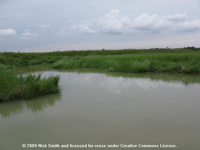 (Click photo for larger view) |
Thanet, Stonar |
|
|
|
Kent Online Parish Clerks |
|
|
(Click photo for larger view) |
Thanet, Stonar |
|
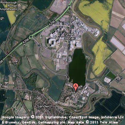 Click on map to view full size on Google Maps. |
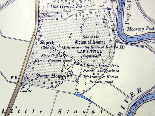 Click here for larger image of this 1881 survey. Click map for modern Ordnance survey map. Reproduced from Ordnance Survey map data by permission of Ordnance Survey, © Crown copyright. |
 We are sorry, there is no Online Parish Clerk for this parish. We are sorry, there is no Online Parish Clerk for this parish.We have no other information or data for this parish except what is accessed by or detailed on this page. If you wish to volunteer for this post or have data you wish to contribute, please use the appropriate link on our Contacts page. |
Statistical SummaryAcres: 670OS co-ordinates: TR335591 Latitude: 51:17.0091N Longitude: 1:20.8732E Parish Church: None Registers commence: Not applicable Other Denominations: None Markets: Monday - St. Nicholas at Wade Wednesday - Ramsgate Thursday - Sarre Friday - Minster Saturday - Monkton, Margate & Ramsgate Fairs: Palm Monday - Minster 30 May - Acol 13 July - Minster 22 July - Monkton 10 Aug - St. Lawrence 8 Sep - St. Nicholas at Wade 14 Oct - Sarre Newspapers: weekly at Ramsgate Electoral Place: Ramsgate Courts: Petty Sessions and County Courts - Margate and Ramsgate Jails: at St. Clement's, Sandwich |
Hospitals: Royal National at Westgate Amenities: None Registration District: Thanet Poor Law Union: Thanet 1835-1930 Workhouse: Minster, Thanet Diocese: Canterbury Archdeaconry: Canterbury Deanery: Westbere Probate: pre-1859 - Archdeaconry Court of Canterbury post-1858 - Principal Probate Registry Lathe: St. Augustine Hundred: Ringslow Houses: 8.1 Parishes within 6 mile radius: Acol, Ash (Sandwich), Birchington Chislet, Elmstone, Margate, Minster in Thanet, Monkton, Preston (Ash and Wingham), Stonar, Reculver, Sandwich (Sts Clement, Mary and Peter), Sarre, St. Nicholas at Wade, Stourmouth, Thanet St Lawrence, Thanet St. Peter |
 Domesday Reference: None Principal landholder: None |
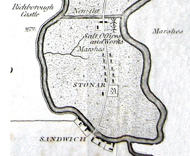
Thanet, St. PeterStonar is a quondam town and a parish in Thanet district, Kent. The town stood on the river Stour, 1 mile north-north-east of Sandwich; is supposed to have been the Lapis Titnli of the Romans; was the place of Louis the Dauphin's debarkation in 1216, and of Edward III.'s embarkation in 1359; was destroyed by the French in 1385; figured as a member of Sandwich in 1773; and is now represented by only a farm house. Post town, Sandwich. Real property, £1,546. The living is a rectory in the diocese of Canterbury. Value, not reported. Patron, the Crown, by lapse. There is no church.1 Stonar was written anciently Eastanore and Eastanores, meaning perhaps the Eastern Ore, in contradistinction to the other place of the same name near Faversham, still called Ore, both which belonged formerly to the Monastery of St. Augustine at Canterbury. After the water had retired from Ebbsfleet, Stonar became the common place of debarkation in the Isle of Thanet; and during the three centuries immediately succeeding the Conquest, it was a considerable place. Dr. Harris quotes a manuscript of Dr. Plot, dated about 1693, which says, that "the ruins of Stonar, till within the memory of man, took up many acres of ground, but were lately removed to render the ground fit for tillage." its prosperity however, we may presume, was checked by the growth of the opposite haven of Sandwich, and by the alteration in the course of the Wantsume. In the 39th year of the reign of Edward III. a sad disaster befel the town in "a terrible inundation of the sea," which overwhelmed a great part of it: and in the year 1385, it was entirely destroyed by the French, who, after having pillaged it, burnt it to the ground. Camden and Dr. Plot are of opinion that the Portus Rutupensis was at Stonar, which at that time stood in the same situation with respect to the city of Rutupiae, that Leith does now to Edinburgh. Besides the piratial attack of the French mentioned above, this port was on two preceding occasions the landing place of an invading enemy; in the year 1009, of Turkill, the Dane; and in the last year of King John's reign, of Lewis, the Dauphin, who brought with him a numerous army. South Stonar House, in the ancient Parish of Stonar, the residence of J. Wood, Esq., is situated at the southern point of the Isle of Thanet, distant from Sandwich not quite half a mile north.4 The civil parish of the same name at the 1921 census was coextensive with the ecclesiastical parish.3 1John Marius Wilson, comp. The Imperial Gazatteer of England and Wales. (London, England: A. Fullerton & Co., 1870). 2Edward Hasted, ed. and comp. The town and parish of Stonar: Town and manors, The History and Topographical Survey of the County of Kent: Volume 4 (1798), pp. 260-307. 3William Page, 1861-1934, ed. The Victoria County History of Kent, vol. 3, p. 360.(London, England: The St. Catherine Press, Stamford Street, Waterloo, S.E., 1932). 4C. Greenwood, comp. Epitome of County History, vol. 1, County of Kent. (London, England: privately printed, 1838). Thanet, St. Peter's Bibliography-- various. 'Archaeologia Cantiana'. Publisher: Kent, England: Kent Archaeological Society, various dates. [Note: The following volumes can be found on archive.org: 1, 2, 3, 4, 5, 6, 7, 8, 9, 10 (1876), 11, 12, 13 (1880), 14, 15, 16, 17, 18, 19, 20, 21, 22, 23, 24, 25, 26, 27, 32, 34, 35, vol. 1907 supplement.]
Great Britain, Public Record Office. 'Calendar of the patent rolls preserved in the Public Record Office--Edward II, Vol. 1. 1307-1313'Each volume has own index. Publisher: Genealogical Society of Utah d.b.a Historical Books on FamilySearch; http://www.familysearch.org. Great Britain, Public Record Office. 'Inquisitions and assessments relating to feudal aids : with other analogous documents preserved in the Public Record Office, A. D. 1284-1431', Vol. 3. Publisher: Genealogical Society of Utah d.b.a Historical Books on FamilySearch; http://www.familysearch.org. Great Britain, Exchequer. 'The book of fees commonly called testa de nevill, pt. 3'. The Book of fees contains information about the holdings of feudal tenants. Publisher: Genealogical Society of Utah d.b.a Historical Books on FamilySearch; http://www.familysearch.org. Hall, Hubert, 1857-1944. 'The Red book of the Exchequer - Liber rubeus de Scaccario, Vol. 3'. The Red book of the Exchequer was a register intended to preserve important documents comprising charters, statutes of the realm, public acts (Placita), private deeds and ordinances, correspondence. Publisher: Genealogical Society of Utah d.b.a Historical Books on FamilySearch; http://www.familysearch.org. Glencross, Reginald Morshead. 'Administrations in the Prerogative Court of Canterbury, Vol. 1. 1559-1571'. Publisher: Genealogical Society of Utah d.b.a Historical Books on FamilySearch; http://www.familysearch.org. Hasted, Edward. 'The History and Topographical Survey of the County of Kent; Containing the antient and present state of it, civil and ecclesiastical; collected from public records, and other authorities: illustrated with maps, views, antiquities, etc. The second edition, improved, corrected, and continued to the present time'. 12 volumes. Publisher: Canterbury: Printed by W. Bristow, 1797-1801. URL: British History Online Hussey, Arthur. 'Notes on the churches in the counties of Kent, Sussex, and Surrey, mentioned in Domesday book, and those of more recent date'. Publisher: London J.R. Smith,(1852). Letters, Dr. Samantha. 'Kent', Gazetteer of Markets and Fairs in England and Wales to 1516 (2005). URL: British History Online. Page, William, 1861-1934, ed.. 'The Victoria history of the county of Kent'. Publisher: London: Constable (1908). URL: British History Online Sharp, J. E. E. S., ed.. 'Inquisitions Post Mortem, Edward I, File 39', Calendar of Inquisitions Post Mortem, Volume 2: Edward I. Published:(1906), pp. 315-323. URL: British History Online. Sharp, J. E. E. S., ed.. 'Inquisitions Post Mortem, Henry III, File 45', Calendar of Inquisitions Post Mortem, Volume 1: Henry III. Published:(1904), pp. 296-302. URL: British History Online. Location of RecordsThe following list of records is not intended to be exhaustive. There are many records that are awaiting discovery in archive offices throughout Kent and England. This list is intended only to set out those records that are available via at least two relatively easy-to-access avenues. If you have used or discover a record that would be of benefit to other researchers, that is not on this list, please send me an email with the details of the archive - name, address and archival call number. Census
Church Records, Church of England
Church Records, Non-Conformist
Parish chest records
Workhouse and Poor Law Records
Land Records
Assizes and Sessions Records
|
| Record Type | Dates | Archives (Addresses) |
Corresponding LDS Family History Library film numbers (Find a centre near you) |
| Hearth tax | Currently under revision | ||
| Victuallers Recognizances | Currently under revision | ||
| Churchwarden's Presentments | Currently under revision | ||
| Parish rate books | Currently under revision |
| Record Type | Dates | Archives (Addresses) |
Corresponding LDS Family History Library film numbers (Find a centre near you) |
| Currently under revision | |||
Coming Soon
1801 - 33
1811 - 51
1821 - 44
1831 - 52
1841 - 52
1851 - 44
1861 - 42
1871 - 35
1881 - 35
1891 - 25
1901 - 59
1911 - 66
1921 - 10
London 64.1 mi.
Canterbury 12.1 mi.
Ashford 23.6 mi.
Bromley 58.0 mi.
Chatham 35.5 mi.
Cranbrook 38.1 mi.
Dartford 50.9 mi.
Deptford 61.1 mi.
Dover 12.5 mi.
Faversham 19.9 mi.
Folkestone 17.2 mi.
Gravesend 43.0 mi.
Greenwich 59.2 mi.
Hythe 19.8 mi.
Maidstone 35.6 mi.
Margate 5.7 mi.
Milton Regis 26.8 mi.
Queenborough 27.0 mi.
Stonar 3.6 mi.
Rochester 38.1 mi.
Sandwich 1.9 mi.
Sheerness 27.5 mi.
Tenterden 32.9 mi.
Tunbridge Wells 48.5 mi.
Woolwich 57.0 mi.
 |
Contact Us Privacy Policy Terms of Use |
© 2006-2015 Kent Online Parish Clerks, all rights reserved. No part of this page or web site may be reproduced either in part or in its' or their entirety in any manner whatsoever without prior written permission of Kent Online Parish Clerks or its' assigns or successors, as the case may be, and the author hereof. |
|