 |
 |
Kent Online Parish Clerks |
|
 |
 (Click photo for larger view) |
Thanet, Ramsgate Parish |
|
|
|
Kent Online Parish Clerks |
|
|
(Click photo for larger view) |
Thanet, Ramsgate Parish |
|
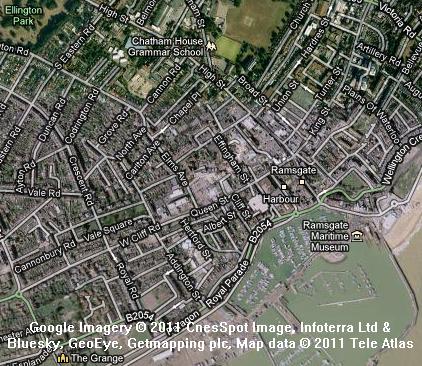 Click on map to view full size on Google Maps. |
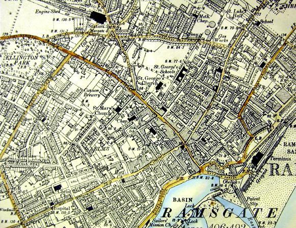 Click here for larger image of this 1881 survey. Click map for modern Ordnance survey map. Reproduced from Ordnance Survey map data by permission of Ordnance Survey, © Crown copyright. |
 We are sorry, there is no Online Parish Clerk for this parish. We are sorry, there is no Online Parish Clerk for this parish.We have no other information or data for this parish except what is accessed by or detailed on this page. If you wish to volunteer for this post or have data you wish to contribute, please use the appropriate link on our Contacts page. |
Statistical SummaryAcres: 356 of which 95 are waterOS co-ordinates: TR 383 649 Latitude: 51:20.0150N Longitude: 1:25.1761E Parish Church: St. Lawrence Registers commence: 1559 Other Denominations: six dissenting chapels Roman Catholic chapel Jewish synagogue Markets: Monday - St. Nicholas at Wade Wednesday - Ramsgate Thursday - Sarre Friday - Minster Saturday - Monkton, Margate & Ramsgate Fairs: Palm Monday - Minster 30 May - Acol 13 July - Minster 22 July - Monkton 10 Aug - St. Lawrence 8 Sep - St. Nicholas at Wade 14 Oct - Sarre Newspapers: weekly at Ramsgate Electoral Place: Ramsgate Courts: Petty Sessions and County Courts - Margate and Ramsgate Jails: at St. Clement's, Sandwich |
Hospitals: Royal National at Westgate Amenities: Post office coast-guard station head port dispensary publishes a weekly newspaper head post-office money order office savings bank railway station with telegraph two banking offices eight chief hotels a market place a town hall a custom house assembly rooms a music hall elegantly fitted baths two good libraries Registration District: Thanet Poor Law Union: Thanet 1835-1930 Workhouse: Minster, Thanet Diocese: Canterbury Archdeaconry: Canterbury Deanery: Westbere Probate: pre-1859 - Archdeaconry Court of Canterbury post-1858 - Principal Probate Registry Lathe: St. Augustine Hundred: Ringslow Houses: 2,209.1 |
 Domesday Reference: None Principal landholder: None Parishes within 6 mile radius: Acol, Ash (Sandwich), Birchington Chislet, Elmstone, Margate, Minster in Thanet, Monkton, Preston (Ash and Wingham), Reculver, Sandwich (Sts Clement, Mary and Peter), Sarre, St Nicholas at Wade, Stonar, Stourmouth, Thanet St Lawrence, Thanet St. Peter |
Thanet, St. PeterRamsgate is a town, a parish, and a sub-district in Thanet district, Kent. The town stands on the coast, in an opening between cliffs, at the north side of the entrance of Pegwell Bay, and at a meeting point of the Southeastern and the London, Chatham and Dover railway systems, 3-1/2 miles south-south-west of the North Foreland, and 4 miles south-south-east of Margate; takes its name from Ruim, the ancient British designation of Thanet, and the "gate" or opening between the cliffs; was only a small fishing village about the beginning of last century (1700); began then to have a good commerce with Russia and the East country; acquired importance from the construction of a pier harbour at it in 1750-95; rose thence into increasing prominence as a seat of trade; was the place where George IV embarked for Hanover in 1821, and where the King and Queen of the Belgians landed in 1837; figures now as a well-frequented watering place, slightly more aristocratic than Margate. Ramsgate consists of two portions, ancient and modern, - the former occupying a depression of the chalk cliffs, - the latter containing the principal streets, with handsome crescents and terraces; commands a delightful prospect of coast and sea; possesses all kinds of excellent appliances for the use of sea-bathing visitors; is a seat of petty sessions and county courts, a polling-place, a coast-guard station, and a head port; publishes a weekly newspaper; and has a head post-office, a money order office and a savings bank, a railway station with telegraph, two banking offices, eight chief hotels, a market place, a town hall, a custom house, assembly rooms, a music hall, an obelisk commemorative of George IV's embarkation, elegantly fitted baths, three churches, six dissenting chapels, a Roman Catholic chapel, a Jews' synagogue, two good libraries, several public schools, a dispensary and charities £59. Markets are held on Wednesdays and Saturdays; supplies for the markets are brought by vessels from the French coast; ship-repairing, rope-making, brewing and fishing are carried on; much business arises from the presence of numerous yachts, the plying of steam packets, and the visits of ships seeking refuge in the harbour; and a considerable commerce, both coastwise and with the continent is carried on. The parish includes part of Ellington hamlet, yet is regarded as conterminate with Ramsgate town; it formed part of St. Lawrence parish till 1827; and it was cut ecclesiastically into the sections of St. George and Christ Church in 1856. Acres 356; of which 95 are water. Real property £66,866; of which £265 are in gas-works. Population in 1851 was 11,838 and in 1861 was 11,865. Houses 2,209. Numerous mansions and villas are either within the parish or in its immediate vicinity; and a Gothic villa, built by A. W. Pugin, Esq. and long inhabited by him, is on the Parade. The sub-district contains also the parishes of St. Lawrence and St. Peter. Acres 8,098. Population 18,007. Houses, 3,449. Ellington, a hamlet in St. Lawrence and Ramsgate parishes, Kent; near Ramsgate. Ellington House was the seat of the Thatchers, and passed to the Spracklyns and the Garrets; and, in 1652, in the time of the Spracklyns, was the scene of a horrible domestic tragedy.1 The civil parish of the same name at the 1921 census was coextensive with the ecclesiastical parish.3 The Ville of Ramsgate, as it is legally termed, is an appendage to the neighbouring parish of St. Lawrence. Since it has become a fashionable watering-place, a large Chapel of Ease has been built. Its other accommodations for visitors resemble those of Margate, but are hardly perhaps on a scale of equal splendour.4 Ramsgate, as appears from the maritime survey in the 8th of Elizabeth, consisted at that time of no more than 25 houses; and but 14 vessels, from three to 16 tons burden, belonged to the port. After the accession of William III. the inhabitants embarked much in the increasing trade with Russia and the East, which greatly benefited the place. But most of its increase is the result of the important improvements in the harbour since the middle of the last century.4 Ramsgate Harbour1The harbour occupies an area of about 45 acres; is formed, almost circularly, by two stone piers; has an entrance 240 feet wide; and includes a patent slip 480 feet long and 60 feet wide. The east pier is nearly 3,000 feet long; the west pier is 1,500 feet long; each pier is 26 feet wide, and forms a fine promenade, and a lighthouse is on the west pier, showing a red light, 37 feet high and visible at the distance of 6 miles. The vessels belonging to the port, at the beginning of 1864 were 98 small sailing vessels, of aggregately 2,747 tons; 26 large sailing vessels, of aggregately 3,928 tons; and 1 steam vessel of 19 tons. The vessels which entered, in 1863, were 9 British sailing vessels of aggregately 921 tons, coming from foreign countries; 3 foreign sailing vessels, of aggregately 490 tons, coming from foreign countries; 434 sailing vessels of aggregately 33,960 tons, coming from coastwise; and 11 steam vessels, of aggregately 1,402 tons, coming from coastwise. The vessels which cleared, in 1863, were 7 British sailing vessels of aggregately 662 tons, proceeding to foreign countries; 4 foreign sailing vessels, of aggregately 580 tons, proceeding to foreign countries; and, 33 sailing vessels, of aggregately 2,918 tons, proceeding coastwise. The amount of customs, in 1867, was £2,721. Construction of Ramsgate Harbour4In the winter of 1748, a violent storm demonstrated the peculiar utility of a sufficient harbour in the precise situation of Ramsgate for ships driven from their anchorage in the Downs. The winds which most distress vessels lying in that open road would carry them directly to this very port; from which, besides, the Downs are exactly at such a distance as to allow a ship time to get properly under sail in order to make the harbour. Accordingly, in the storm just alluded to, a number of ships were saved by taking refuge here, notwithstanding the deficiency of the shelter. This circumstance excited the attention of the public, and an Act was passed to make the harbour serviceable for vessels of and under 300 tons burthen. The trustees immediately commenced the construction of two new piers, to supersede the old one, which was very inconsiderable, having been built merely by the fishermen of the place. The east pier, it was resolved, should be built of stone, the west pier of wood. For three or four years the work had proceeded with alacrity, when a difference of opinion took place in the committee, the majority deciding that the harbour should be contracted to an area of 1,200 feet. This, it was justly complained, would have the effect of making it in great measure useless to the public; and the dispute had the effect of putting an entire stop to the work till 1769, when the previousl resolution was reversed, the contracting walls were removed, and operations recommenced with great spirit. But about 1773 it appeared, that under the angles that had been formed at the head of the piers, in order to bring their extremities nearer to each other, the sand accumulated so rapidly, and in such quantities, that the harbour was likely to be entirely filled. After struggling in vain for a few years longer against this new obstruction, the directors were thoroughly discouraged, and advised, in their published report, that nothing more should be done at the harbour till Mr. Smeaton, (the celebrated builder of the Eddystone Lighthouse,) or some other very able engineer, should have an opportunity of surveying it. Indeed, at this time the harbour was in so forlorn a state, that the public reprobated the idea of spending any more money on so useless a labour. When Mr. Smeaton undertook the survey, he observed, that at low water there was no water to be seen in the harbour, except a small roundish area just within the pier heads, and at spring tides none, but what lay immediately between the heads. At this period two barges were always employed, which indeed is still the case, with 10 men in each, to remove the sullage. Mr. Smeaton ascertained that, at this rate, in 12 years the harbour would not be cleared, even supposing that no fresh sand were continaully depositing. As at Ramsgate there is no river to keep an open channel, he recommended that a large basin should be formed, and furnished with sluices to receive and take in the sea water, and transmit it at proper intervals against the mud. The material part of his proposal was acted upon. The whole of the inner part of the harbour was converted into basin, for the purpose thus suggested; and in 1779 the sluices were opened, and their success far surpassed the general expectation. Such force had the rush of water, that for a mile beyond the pier head the sea was observed to be clouded with the mud, which was dislodged in vast quantities. Indeed, so violent was the current, that in some places it tore up large masses of the chalk rock, upon which the silt had embedded itself at the bottom of the harbour. This advantage, however, was found to be accompanied, on the other hand, with considerable inconvenience. The swell of the sea being broken by the wall across the harbour, that formed the inner part into a basin, the waters of the outer harbour became in rough weather dangerously restless. To remedy the mischief, 2 or 300 feet of this wall was taken down, and from the shortened end another was carried up towards the cliff; so that at one side the whole length of the harbour was left unobstructed. To obtain a still freer passage, an interval of 80 or 100 feet was likewise made in the middle of the timber pier. By these means the agitation of the water was materially diminished. But as it was still found very considerable in strong gales, especially from the east and south-east, the head of the east pier, agreeably to the opinion of the most experienced pilots and seamen of Ramsgate, was prolonged in a south-easterly direction; and a storehouse and dry dock being completed about the same time, for the supply and repair of damaged vessels, the utility of the harbour became more and more apparent, in the increasing number of ships that here sought shelter. A new stone lighthouse was afterwards erected on the head of the west pier, the basin wall was widened into a wharf, the wooden pier has since been rebuilt with stone, about the close of the last century a military road was constructed for the embarkation of troops from the pier head, and great additional improvements have been made. During the storm of December 1795, more than 300 vessels were sheltered here at once, some of them of 500 tons burden and upwards. In 1780 not more than 29 vessels had recourse to this harbour. Subsequently the number rose to the amount of 5, 6, 7, and even 800. The harbour now has a depth of about 19 feet at spring tides. Its area is nearly circular, and comprises about 46 acres. The piers are about the breadth of 26 feet, and built of Portland and Purbeck stone; mostly of the latter. The east pier extends 2000 feet in a straight line; the west, including its angles, has a length of 1200 feet. A large sand-bank stretches across the harbour, leaving a free channel under the east pier. This bank, so far from being an inconvenience, is of great use to ships in bringing up upon it in stormy weather, when deprived of their ancors and cables, as well as for supplying them with ballast on leaving the harbour. The mouth of the harbour being so far advanced into the open sea, the entrance of a ship in boisterous weather, amid the rolling and spray of the waves, is an imposing spectacle: and during the fasionable season the east pier becomes a favourite promenade. ChurchesSt. George's church was built in 1827 at a cost of £30,000; is in a florid pointed style, with tower and spire 137 feet high; measures 148 feet by 68-1/2 feet; and contains 2,000 sittings. The living of St. George is a vicarage, in the diocese of Canterbury. Value of St. George £400 with a habitable glebe house. Patron of St. George is the Archbishop of Canterbury.1 The living of Christ Church is a vicarage, in the diocese of Canterbury. Value not reported. Patron of Christ Church, Trustees.1 The chapel of ease was built in 1791 and was recently improved. The living of the chapel of ease is a perpetual curacy, in the diocese of Canterbury. Value not reported. Patron of the chapel of ease, the Vicar of Ramsgate.1 There are also six dissenting chapels, a Roman Catholic chapel, and a Jews' synagogue.1 SchoolsThere are several public schools1 CharitiesThere are charities amounting to £59.1 1John Marius Wilson, comp. The Imperial Gazatteer of England and Wales. (London, England: A. Fullerton & Co., 1870). 2Edward Hasted, ed. and comp. The town and parish of Ramsgate: Town and manors, The History and Topographical Survey of the County of Kent: Volume 4 (1798), pp. 260-307. 3William Page, 1861-1934, ed. The Victoria County History of Kent, vol. 3, p. 360.(London, England: The St. Catherine Press, Stamford Street, Waterloo, S.E., 1932). 4C. Greenwood, comp. Epitome of County History, vol. 1, County of Kent. (London, England: privately printed, 1838). Thanet, St. Peter's Bibliography-- various. 'Archaeologia Cantiana'. Publisher: Kent, England: Kent Archaeological Society, various dates. [Note: The following volumes can be found on archive.org: 1, 2, 3, 4, 5, 6, 7, 8, 9, 10 (1876), 11, 12, 13 (1880), 14, 15, 16, 17, 18, 19, 20, 21, 22, 23, 24, 25, 26, 27, 32, 34, 35, vol. 1907 supplement.]
Great Britain, Public Record Office. 'Calendar of the patent rolls preserved in the Public Record Office--Edward II, Vol. 1. 1307-1313'Each volume has own index. Publisher: Genealogical Society of Utah d.b.a Historical Books on FamilySearch; http://www.familysearch.org. Great Britain, Public Record Office. 'Inquisitions and assessments relating to feudal aids : with other analogous documents preserved in the Public Record Office, A. D. 1284-1431', Vol. 3. Publisher: Genealogical Society of Utah d.b.a Historical Books on FamilySearch; http://www.familysearch.org. Great Britain, Exchequer. 'The book of fees commonly called testa de nevill, pt. 3'. The Book of fees contains information about the holdings of feudal tenants. Publisher: Genealogical Society of Utah d.b.a Historical Books on FamilySearch; http://www.familysearch.org. Hall, Hubert, 1857-1944. 'The Red book of the Exchequer - Liber rubeus de Scaccario, Vol. 3'. The Red book of the Exchequer was a register intended to preserve important documents comprising charters, statutes of the realm, public acts (Placita), private deeds and ordinances, correspondence. Publisher: Genealogical Society of Utah d.b.a Historical Books on FamilySearch; http://www.familysearch.org. Glencross, Reginald Morshead. 'Administrations in the Prerogative Court of Canterbury, Vol. 1. 1559-1571'. Publisher: Genealogical Society of Utah d.b.a Historical Books on FamilySearch; http://www.familysearch.org. Hasted, Edward. 'The History and Topographical Survey of the County of Kent; Containing the antient and present state of it, civil and ecclesiastical; collected from public records, and other authorities: illustrated with maps, views, antiquities, etc. The second edition, improved, corrected, and continued to the present time'. 12 volumes. Publisher: Canterbury: Printed by W. Bristow, 1797-1801. URL: British History Online Hussey, Arthur. 'Notes on the churches in the counties of Kent, Sussex, and Surrey, mentioned in Domesday book, and those of more recent date'. Publisher: London J.R. Smith,(1852). Letters, Dr. Samantha. 'Kent', Gazetteer of Markets and Fairs in England and Wales to 1516 (2005). URL: British History Online. Page, William, 1861-1934, ed.. 'The Victoria history of the county of Kent'. Publisher: London: Constable (1908). URL: British History Online Sharp, J. E. E. S., ed.. 'Inquisitions Post Mortem, Edward I, File 39', Calendar of Inquisitions Post Mortem, Volume 2: Edward I. Published:(1906), pp. 315-323. URL: British History Online. Sharp, J. E. E. S., ed.. 'Inquisitions Post Mortem, Henry III, File 45', Calendar of Inquisitions Post Mortem, Volume 1: Henry III. Published:(1904), pp. 296-302. URL: British History Online. Location of RecordsThe following list of records is not intended to be exhaustive. There are many records that are awaiting discovery in archive offices throughout Kent and England. This list is intended only to set out those records that are available via at least two relatively easy-to-access avenues. If you have used or discover a record that would be of benefit to other researchers, that is not on this list, please send me an email with the details of the archive - name, address and archival call number. Census
Church Records, Church of England
Church Records, Non-Conformist
Parish chest records
Workhouse and Poor Law Records
Land Records
Assizes and Sessions Records
|
| Record Type | Dates | Archives (Addresses) |
Corresponding LDS Family History Library film numbers (Find a centre near you) |
| Hearth tax | Currently under revision | ||
| Victuallers Recognizances | Currently under revision | ||
| Churchwarden's Presentments | Currently under revision | ||
| Parish rate books | Currently under revision |
| Record Type | Dates | Archives (Addresses) |
Corresponding LDS Family History Library film numbers (Find a centre near you) |
| Currently under revision | |||
1749 - Act of parliament passed giving approval for the construction of a new harbour at Ramsgate. Prior to that (dating back to Roman times) Ramsgate had been a very small fishing village, with only a wooden pier forming the tiny harbour.
1802 The first lifeboat, built by Henry Greathead, was provided by the Trustees of Ramsgate Harbour.
1820 - Ships lost in gales October and November.
1826 - August. Ramsgate made a distinct parish after separation from St. Lawrence parish by act of parliament.
1845 - 12 October. Elizabeth Fry died from a stroke at Ramsgate. Her remains were buried in the Friends' burial ground at Barking. Until this occasion, the Seamen of the Ramsgate Coast Guard flew their flag at half mast in respect of Mrs. Fry.
1846 - April. South Eastern Railway trains first reached Ramsgate from Canterbury. It terminated at Ramsgate SER, later to be called Ramsgate Town, which, unlike the present-day station, was in the town centre.
1851 - The lifeboat station, which had lapsed sometime before 1824, was re-opened.
1886 - 18 November. Fishermen's riot at Ramsgate.
1891 - 15 December. The Enterkin, bound to Brisbane with a cargo of iron, was wrecked off Ramsgate on Saturday night. An apprentice, who was lashed to the rigging, was the only one of the crew rescued. All the rest on board, thirty in number, were drowned.
1895 - 31 January. Terrible snowstorm in the Channel caused disappearance of lifeboat and tug, later found with all aboard, many with frostbite.
1903 - 26 February. Tragedy of the Samuel Henson family.
1905 - 9 January. Damaging tidal floods.
1905 - 3 Aug Ramsgate tramcar, descending East Cliff, toppled over, falling 70 feet. Five persons were injured.
1801 - 3110
1811 - 4221
1821 - 6031
1831 - 7985
1841 - 10909 - 1841 includes 226 persons on board vessels in the harbour. Ramsgate was created a parish, out of St. Lawrence Parish, in 1827.
1851 - 11838
1861 - 11865
1871 - 14640
1881 - 16234
1891 - 16253
1901 - 16503
1911 - 15671
1921 - 19561
London 66.8 mi.
Canterbury 15.5 mi.
Ashford 27.3 mi.
Bromley 60.9 mi.
Chatham 38.5 mi.
Cranbrook 41.7 mi.
Dartford 53.7 mi.
Deptford 63.9 mi.
Dover 14.9 mi.
Faversham 23.1 mi.
Folkestone 20.3 mi.
Gravesend 45.8 mi.
Greenwich 62.0 mi.
Hythe 23.1 mi.
Maidstone 38.9 mi.
Margate 4.2 mi.
Milton Regis 29.8 mi.
Queenborough 29.6 mi.
Rochester 41.1 mi.
Sandwich 4.9 mi.
Sheerness 30.0 mi.
Tenterden 36.5 mi.
Tunbridge Wells 52.0 mi.
Woolwich 59.7 mi.
 |
Contact Us Privacy Policy Terms of Use |
© 2006-2015 Kent Online Parish Clerks, all rights reserved. No part of this page or web site may be reproduced either in part or in its' or their entirety in any manner whatsoever without prior written permission of Kent Online Parish Clerks or its' assigns or successors, as the case may be, and the author hereof. |
|